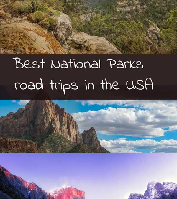
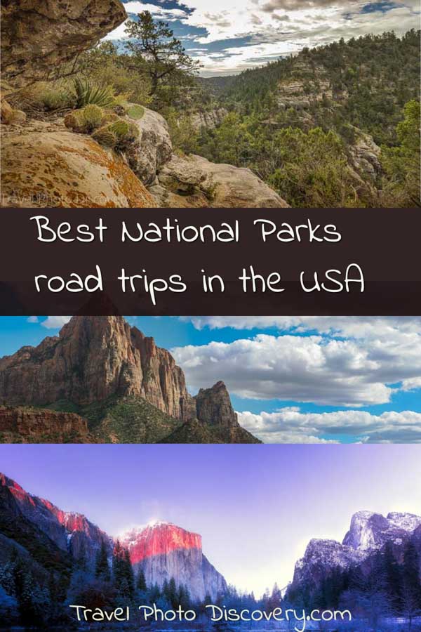
The best USA National Parks scenic road trips
In this post, we created a collaboration of the best scenic road trips and visiting the National Parks of the United States and explore all the stunning landscapes, views and highlights to visiting each national park system.
IF you’re looking for some inspiration when you visit a national park in the USA, check out this national parks road trip planner showcasing the best scenic venues, gorgeous must visit spots and overlook areas, popular attractions and hikes, and must visit sites inside each national park. Most of these tips are shared from travel journalists and bloggers that will tell you more about these special places within the national parks that are a must! Check out best USA National Parks scenic road trips now to start planning your visit soon!
Must do Epic Road Trips through the USA National Parks Now!
What are the best USA national parks scenic road trips to do now?
Plan your national parks road trip around the USA
Below are some of the best national parks detailing the scenic loop roadway in the part and showcase the main attractions, overlook areas, hiking venues and must visit spots around the park to experience and photograph. You’ll find lots of inside tips and other fantastic ideas for visiting each national park so you can start planning your road trip around the United States now.
Central US national parks road trips
Central US National Parks encompass a diverse range of natural wonders, from towering mountains to vast prairies and breathtaking canyons. These parks showcase the region’s rich biodiversity, geological formations, and cultural heritage. Exploring Central US National Parks allows you to witness stunning landscapes, engage in outdoor activities, and immerse yourself in the beauty of nature. Whether you seek rugged adventures or serene tranquility, the Central US National Parks offer an unforgettable journey through some of America’s most cherished landscapes.
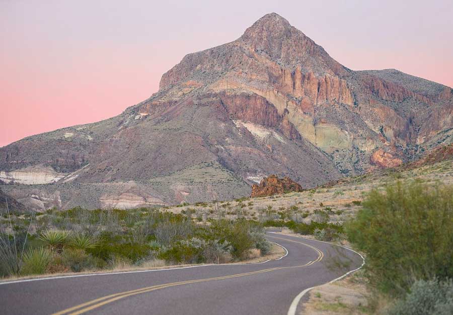
Big Bend National Park
Credit image to Trip Of A Lifestyle
All of Big Bend National Park is scenic. But perhaps the most scenic paved highway is Ros Maxwell Scenic Drive. This thirty-mile drive showcases some of the historic and geologic features this region is famous for. Some of the popular stops include:
Old Sam Nail Ranch – this is an abandoned old ranch building along Cottonwood Creek. It has a working windmill that still pumps water and attracts a variety of birds and wildlife.
Chimneys Trailhead– This is a 5-mile round-trip hike to some beautiful geological formations in the area.
Blue Creek Ranch – a ranch house made out of native rock near the trailhead to Blue Creek Canyon.
Sotol Vista – This scenic lookout provides some of the best panoramic views in the park.
Burro Mesa Pour-Off – a half-mile trail leads into a box canyon and a dramatic high waterfall.
Tuff Canyon – this canyon was formed out of soft volcanic ash. You can view the canyon from the two viewing platforms or hike through the gorge.
Castolon Historic District – This area has remnants from the early 1900’s farming community including an old store, troop barracks, and private residences.
Cottonwood Campground – The campground has campsites with tables, running water, and toilets, underneath shady Cottonwood trees. There is also a store that sells lunch items and ice cream. This is a great spot for watching birds and wildlife.
Santa Elena Canyon -The canyons are 1,500-foot limestone formations that are the most magnificent view in the park. There is a hike along the canyons which provides some of the best views of the Rio Grande.
From this point, travelers may continue ahead on the all-gravel Maverick Road 14 miles back to the western gate of Big Bend National Park, or headlock on the paved road back through Ross Maxwell Drive.
By Mama Pinot, Wine Travel Kids
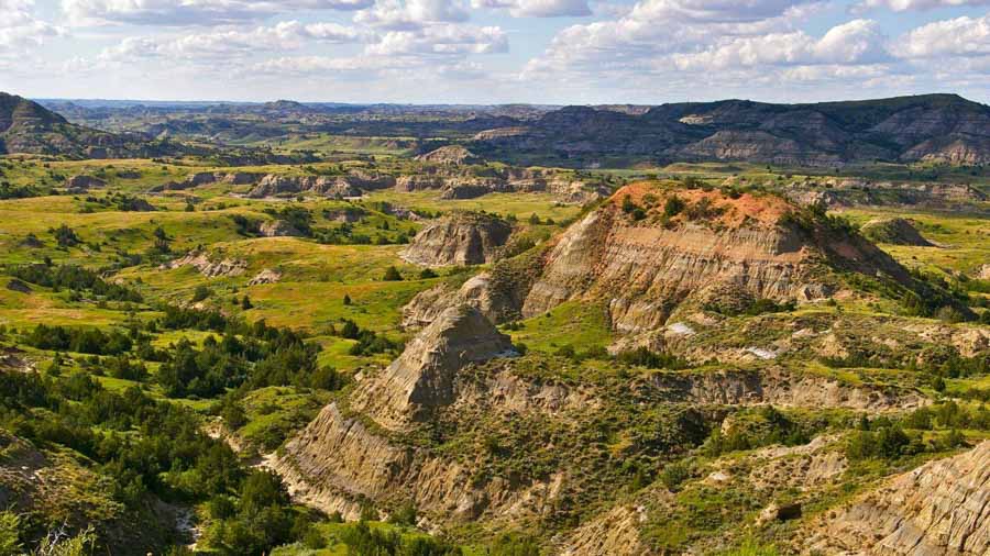
Theodore Roosevelt National Park scenic drives
Theodore Roosevelt is the only national park in North Dakota and is a great national park to take in a scenic drive and some hikes. Located in the southwestern corner of the state, it is usually visited on a road trip from Montana or South Dakota. The best time to visit this park is in the summer, as temperatures are rather cold most of the year.
Theodore Roosevelt National Park has two units, North and South. Both units have scenic driving loops to view the landscape, bison, wild horses, and prairie dogs that inhabit the area. The 36-mile scenic loop in the South Unit is where the majority of the people do visit, as it is closest to the interstate. Parking is not an issue as this is one of the least visited national parks in the country. Some of the best scenic lookouts are Skyline Vista, Boicourt Overlook, Badlands Overlook, Scoria Point, and Buck Hill. The majority of the hiking trails can be found in the South Unit as well. Some of the best trails include Painted Canyon Nature Trail, Wind Canyon Trail, and the Big Plateau Trail. You could also stop at a few of the Prairie Dog Towns around the park to check out if any of them are playing outside. In the North Unit, the scenic drive is much shorter, 14 miles. The best two lookouts are the Oxbow Overlook and River Bend Overlook. The Cannonball Concretions and the Caprock Coulee Trail are the two most popular hikes. There are also a couple of Prairie Dog Towns here too.
Overall, visiting Theodore Roosevelt National Park is great for those looking for a more quiet and rugged national park experience away from the crowds.
Margie with DQ family Travel
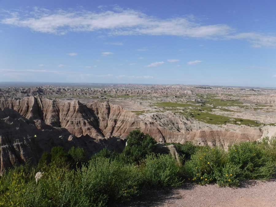
Visiting Badlands National Park scenic drives
The Badlands Loop Road drive through Badlands National Park provides views of hundreds of acres of spectacular spires and pinnacles in the northern unit of the park, along with access to the Visitors Center, hiking trails, and observations points! The three entrances are the Pinnacles (near the famous Wall Drug Store) and NE entrances off Interstate 90, and the Interior entrance off Highway 44, and a National Parks pass is required to enter through any of the three. The Ben Reifel Visitors Center provides fascinating information about the history of the Badlands, from prehistoric days to the present, offers Junior Ranger booklets and programs, and has a working fossil lab that visitors can observe! Near the Visitors Center is Cedar Pass Lodge, with the only cabins for visitors inside the park.
Along the way, there are a dozen observation points, and the Pinnacles Overlook is my recommendation if you can only stop at one (come at dawn for the best chance of seeing bighorn sheep), but if you have time, they’re all worth a look! Access to most of the signed hiking trails are along the Badlands Loop Road, including the Notch Trail with its famous ladder, the 10-mile-long Castle Trail, and the short Fossil Trail with educational panels about the fossils found in the Badlands and a well-kept boardwalk, which is easily accessible to strollers, wheelchairs, and other mobility aides. Open hiking is also allowed throughout Badlands National Park as well! All along the route, visitors will find views of the amazing geologic formations of the Badlands, and if lucky, some of the elusive wildlife as well, including bison, bighorn sheep, and prairie dogs.
Whether you have time to spend all day or just drive through, the Badlands Loop Road is the way to go!
Check out Lindsay’s post on Visiting Badlands National Park with Kids
Western US national parks road trips
Taking a road trip through the Western US National Parks promises awe-inspiring adventures and breathtaking landscapes. From the iconic Grand Canyon to the majestic Yosemite, these parks boast towering mountains, deep canyons, pristine lakes, and unique geological formations. Journeying through the Western US National Parks allows you to witness the raw beauty of nature, encounter diverse wildlife, and partake in thrilling outdoor activities. Immerse yourself in the grandeur of these natural wonders and create unforgettable memories as you traverse the scenic routes of the Western US National Parks.
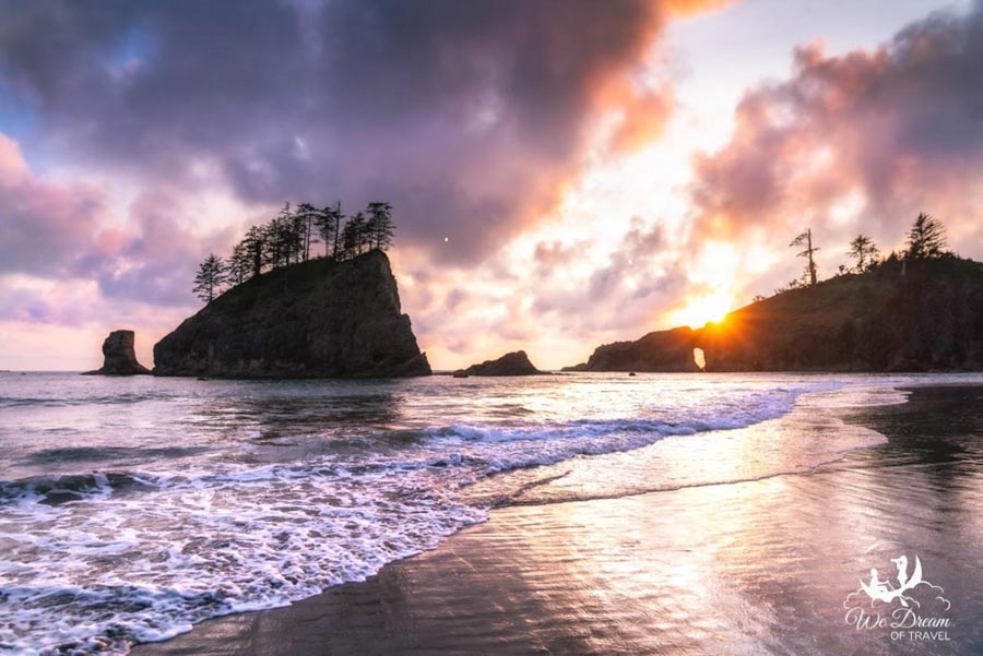
Olympic National Park
Olympic National Park covers almost a million acres and is the most biodiverse of all the US National Parks, it’s therefore no surprise that it makes for one of the most scenic drives. Within the national park you can discover glaciated mountains, verdant rainforest, cascading waterfalls and rugged coastline, as well as a myriad of wildlife. It’s worth taking at least a few days for a road trip around Olympic National Park to truly make the most of all this area has to offer. Also, due to its continuous wet weather, you should be prepared for at least some rain no matter when you visit.
You’ll find a treasure trove of photography locations in Olympic National Park. One of the most beautiful stops is Hurricane Ridge. The views from the parking lot are breathtaking, however there are also a number of different day hikes, or longer trails, to take you to other vantage points to appreciate the scenery. You also won’t want to miss stopping at Sol Duc Falls. To reach the falls requires a moderate 1.5-mile hike, but the idyllic setting amongst lush greenery makes this perhaps the most beautiful waterfall in Washington. There are also hot springs located nearby if you need a bit of relaxation.
For the coastal lovers, Second Beach is the most photogenic option and the nearby town of La Push offers plenty of services. There are endless options to explore in this vast national park. One thing is for sure though, with its host of dramatic landscapes, you won’t be disappointed no matter which direction you drive here!
Sophie with We Dream of Travel
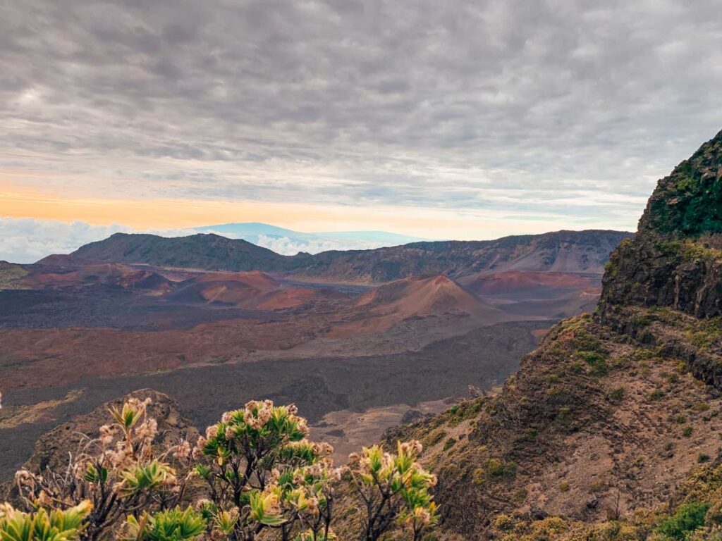
Drive to the top of Haleakala National Park in Maui
If you want to visit at sunrise you must book a ticket in advance as there are limited spaces for sunrise. The temperatures are also extremely cold up here so make sure you bring extra warm clothing.
From the entrance to the parking lot at the top is a stunning 30-minute drive. As you drive up to the top of Haleakala, along a series of steep switchbacks, you start to get incredible views out over the island of Maui and you can see for miles around on a clear day.
The view at the top really is the highlight though. Not only do you get uninterrupted views around the island but you also get to see right into the heart of the colourful volcanic craters. If you are feeling up for it there are several hikes you can enjoy that will take you right down into the craters such as the Keoneheehee Trail and Pipiwai Trail.
The main lookout point is at the Haleakala Visitors Centre, right at the top of Haleakala. If you are looking for a slightly more secluded lookout then you can check out both Leleiwi or Kalahaku overlooks which are a short distance before the visitors’ centre. They offer similar views but with almost no people and are worth stopping at as they give you unique views into the volcanic craters.
This is a spectacular place to visit and the drive up is sensational as more and more of the surrounding landscapes and craters reveal themselves the higher you climb. Next time you visit Maui make sure a trip to the top of Haleakala is on your itinerary!
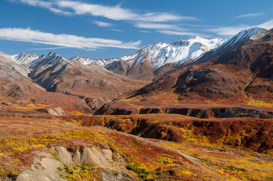
Exploring Denali Park Road
The best road trip inside a national park is hands down, the Denali Park Road. This is the only road into the national park brings you to the foot of North America’s tallest mountain all the while surrounded by magnificent wildlife and grand landscapes. During regular tourist seasons you have to take the bus past the gate at mile 15 but, the Denali park road lottery lets visitors drive their own vehicle the along the entire road. This opportunity has been enhanced under Covid and visitors can drive an extra 20 miles further than usual without the lottery but I still recommend trying for the lottery. You’re guaranteed to see bountiful wildlife since Denali is home to bear, moose, caribou, wolves and much more. The best views of Denali come near Eielson visitor center and some of the best hikes are in the Polychrome Pass but backpackers are certain to enjoy hiking in any zone.
Camping overnight is a great way to make most out of your Denali visit. Whether you camp near the visitor centers at designated camping spots or take a ranger training course before an overnight in the backcountry, you’re sure to enjoy the adventure. My recommendation is to camp near the park entrance the night before your road trip. That way you’ll wake up in the park and have the whole day to explore!
Summer is the high season with a midnight sun making full day excursions well worth it. Fall and spring bring northern lights to the Denali night skies and although the road closes for winter, you can ski, snow machine or even dogsled down through the winter wonderland.
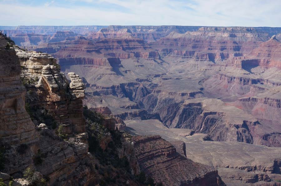
Desert View Drive at the Grand Canyon
When visiting the Grand Canyon, most first-time visitors to this natural world wonder explore the South Rim. It is most popular for its scenic drive, Desert View Drive. The route starts one mile east of Grand Canyon Village, connects a half dozen scenic viewpoints, and ends at Desert View near the east entrance of the park. It is 25 miles of scenic views and takes around 4 hours to complete if you’re stopping to enjoy the breathtaking landscape and outlooks.Navajo Point is the highest point of elevation on the South Rim and has some fabulous panoramic views, though the top of the Desert View Watchtower is slightly taller. Built in the early 1930s, this seventy-foot high watchtower is a short walk from the parking lot bear the east entrance, for picturesque views. At Lipan Point, if you look across to the river, you will notice the tilted layers of the “supergroup”, only visible from a few viewpoints in the Grand Canyon.
If you are looking for an access point to great hiking trails, Pipe Creek Vista offers access to the Rim Trail, a mostly-paved 12-mile hike. To learn about where the ancient Puebolan people lived and how they raised their families in the Grand Canyon region, make a stop at the Tusayan Ruin and Museum. Explore the remains of the village and walk the well-maintained loop around the ruins.
The best time to do the Desert View Drive is in the off-peak months (March-May and September-November), when the temperatures are more comfortable and the excessive summer crowds have gone.
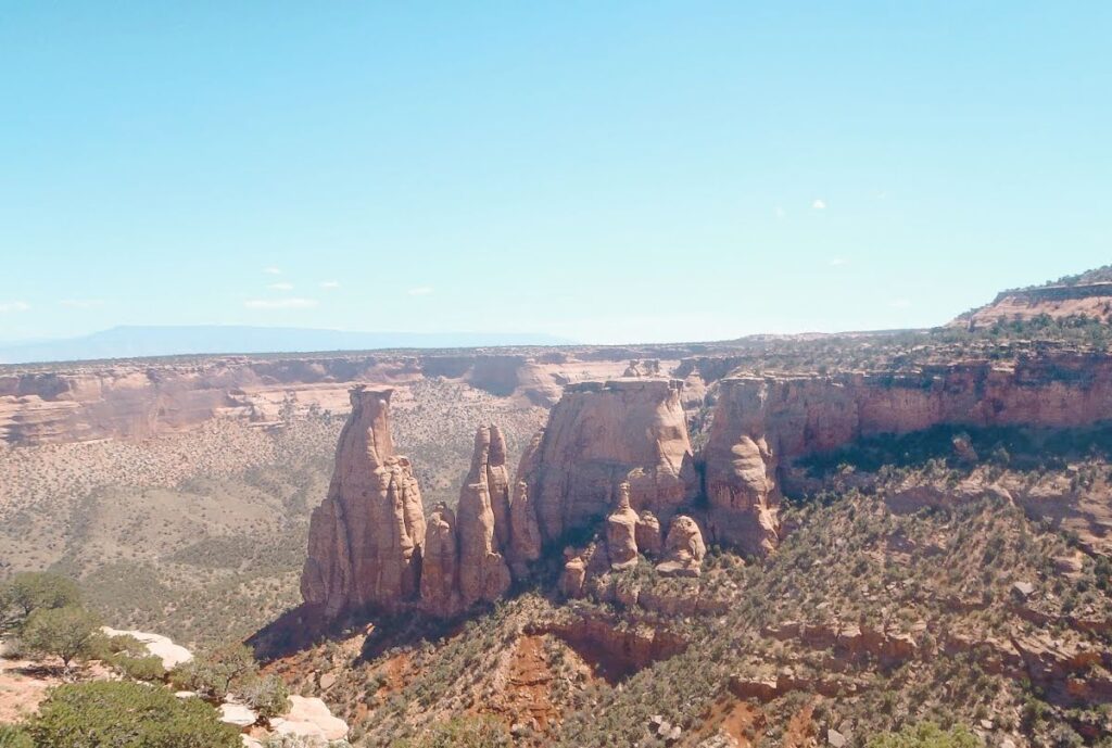
Colorado National Monument Historic Rim Rock Drive Grand Junction, Colorado
If you are looking for world-class desert vistas, take a drive along the scenic Rim Rock Drive. A hidden gem of Western Colorado, the Colorado National Monument is home to one of the best scenic drives!
Geographically part of the intermountain Colorado Plateau, this National Park Service Monument is full of red rock canyons, sandstone towers, and other incredible geologic formations surrounded by pinon-juniper woodlands and sagebrush. The 23-mile historic drive has ample opportunities to pull off, enjoy the views, and capture breathtaking desert-scape photography.
The scenic drive runs east-west and vice versa. Drivers should start at the east entrance near Grand Junction’s Redlands community and wander up the steep switchbacks to the mesa’s top. Visitors are treated to towering sandstone cliffs and even three drive-through tunnels. The desert earth tones make for excellent photo opportunities. There are ten named pull-offs along the way to stop and walk over to the cliff’s edge. Look for signs such as Cold Shivers Point, Red Canyon, Ute Canyon, Coke Ovens, and Monument Canyon to capture fantastic photography. The west end of the drive includes the Visitor Center and will end near the town of Fruita. Drivers should keep an eye out for cyclists as this is a famous road biking route in Colorado.
Independence Monument is one of the most photographed sandstone monoliths of the Park. Visitors can see Independence Monument from the Rim Rock scenic drive; however, the best way to view the famous monolith is to hike the 5-mile loop to the base and back. Hikers can start from the Monument Canyon Loop Trail off Broadway (CO-340). There is a small parking lot on the south side of Broadway. Follow the trail and keep your eyes peeled for bighorn sheep!
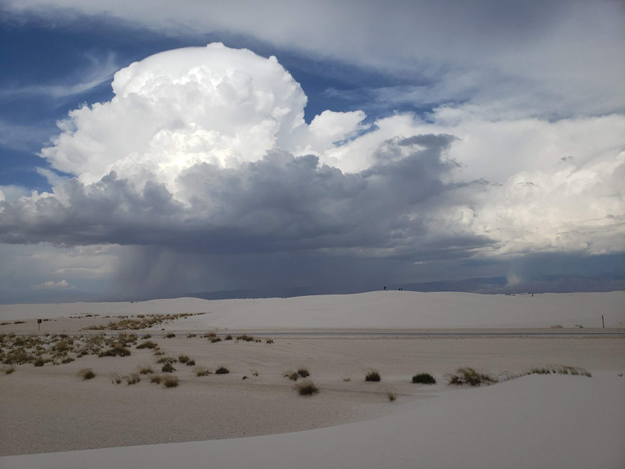
White Sands National Parks scenic drives
One of the best ways to witness one of the most alien-esque landscapes in the US is to take a scenic drive on Dunes Drive in White Sands National Park! New Mexico’s second National Park is home to miles of endless ivory sand dunes, framed by a backdrop of purple San Andres mountains, making it an unrivaled destination for any avid sightsee-er!
Dunes Drive is the main park road that traverses White Sands National Park. It costs $25 to enter the park and access Dunes Drive. Dunes Drive is a 16-mile roundtrip scenic loop that starts at the main Visitor’s Center, winds 8 miles into the backcountry, before looping around back towards the park entrance. Dunes Drive is one of the best National Park scenic drives not only because it is extremely easy to navigate, but it also contains access points to anything and everything available to guests inside the park! Along Dunes Drive, there are multiple panoramic lookout spots, picnic areas, meeting locations for ranger led tours, the trailheads for all of White Sands National Park’s hiking trails, access to backcountry camping, and, one of the highlights of any visit, sand sledding! The best spots for sand sledding can be found along the back of Dunes Drive, and it is as simple as pulling over into one of the many parking areas along the drive, grabbing a sled, and choosing a dune! Sleds are available for purchase at the Visitor’s Center, or bring your own! Occasionally White Sands National Park and its Dunes Drive are closed due to nearby missile range testing, so it is important to check the park’s website for notices before planning your scenic drive!
Kristen with Yonderlust Ramblings
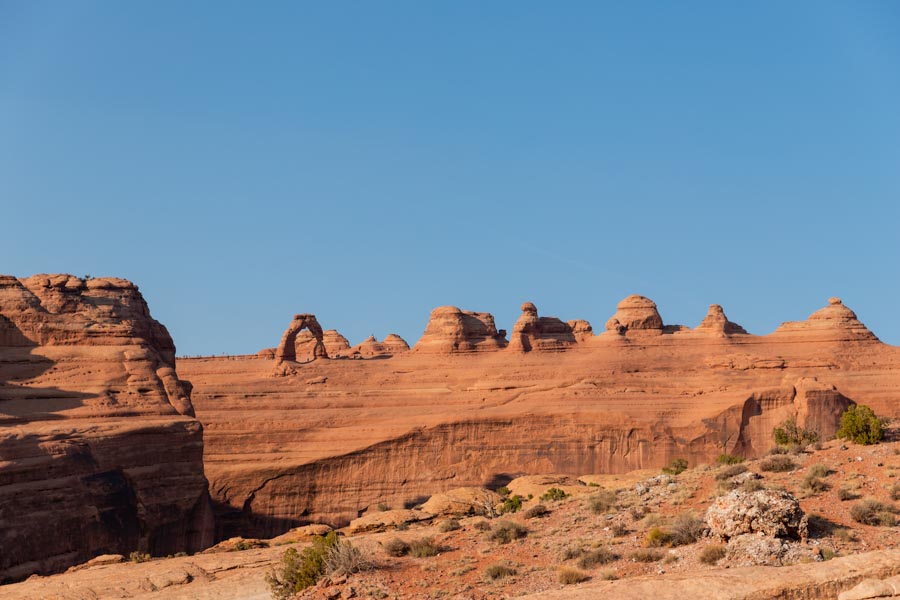
Exploring Arches National Park’s scenic drives
Arches National Park is home to more than 2,000 natural arches. And it also happens to be one of the best locations for a scenic drive. If you do the full roundtrip drive, you’ll cover 36 miles throughout Arches National Park.
You’ll start at the Arches Visitor Center, and slowly make your way to the top. Once you drive the first few miles, it’s like entering another world. Beautiful sandstone all around and some of the coolest sights in the country. The drive can be as short or long depending how many Arches you want to explore.
One of the most famous Arches, Delicate Arch, is also one of the longer hikes. The trail is 3 miles and will take you about 2-3 hours. It’s also one of the best photo spots in the whole park. If you prefer a shorter hike, you can also complete the .5-mile hike to the Delicate Arch viewpoint. It’s not the close up view that you get with the main hike, but it’s still a great photo opp.
Probably the coolest part of the Arches Scenic Drive is that you can see hundreds of arches without ever leaving the comfort of your car. Of course, when you want to get out and explore, there are car park areas everywhere. And many of them, like the famous Balanced Rock, don’t require any hiking. Shut your car door and you’re there.
If you want to do some hiking, in addition to Delicate Arch, other great hikes include: The Windows (1 mile roundtrip), Landscape Arch (1.6 miles roundtrip), Devils Garden Loop Trail (7.2 miles roundtrip), and Double Arch (.5 miles roundtrip).
One of the best reasons to visit the Arches Scenic Drive is that you can partake in as much or as little as you want. There are hikes of every difficulty level, plenty of photo spots, and some of the most beautiful scenery you will ever see.
Check out Brittany’s post on an epic cross country road trip on a budget
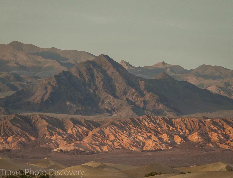
Death Valley National Park Scenic Byway
Spanning over 80 miles, Death Valley Scenic Byway is a historic drive and an incredible experience in one of America’s largest national parks that offers spectacular views of shifting dunes, quirky geological formations, and towering mountains in the background.
While you can do this drive in under two hours, you should take more time to stop at scenic overlooks, so you can appreciate the beauty of this place.
One of the most famous overlooks along Death Valley Scenic Byway is Badwater Basin, Zabriskie Point, and Mesquite Sand Dunes. And don’t forget to make your way up to Dante’s View, near the eastern entrance of the park where you can get an incredible panoramic overlook of the entire Death Valley framed by the dark mountains and salt flats below.
This scenic drive begins near the eastern entrance of the Death Valley National Park and merges with Highway 190 that ends near the western entrance of the park.
While you can drive along Death Valley Scenic Byway year-round, the best time to do so is from late fall through mid-spring when temperatures in Death Valley are mild enough for being outside. The best way to enjoy Death Valley is to get outside your car and take a hike, and since temperatures here are often in triple digits from late spring through mid-fall summer, I recommend sparing your adventure for colder seasons.
When you go on a hike, always remember to carry at least one bottle of water, as you can get dehydrated very quickly. And don’t forget to bring a hat and sunscreen, since the sun can be very strong here.
Entrance to Death Valley costs $35 per vehicle and can be paid at one of the meters at the entrance or the visitor’s center in Furnace Creek.
Daria with The Discovery Nut
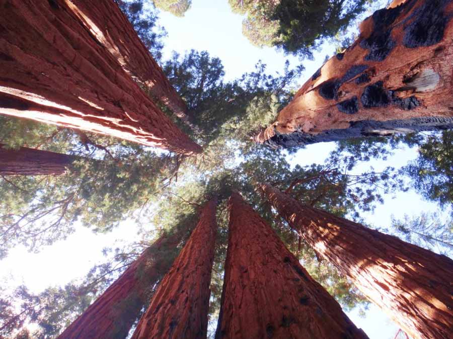
Sequoia National Park
The Generals Highway winds its way through Sequoia National Park and the adjacent Kings Canyon National Parks. Sequoia trees are the largest trees on earth, and the largest of them have been given names. The biggest of them all, called the General Sherman Tree, is in Sequoia National Park. The second largest tree on the planet, the General Grant Tree, is in Kings Canyon National Park. Which is why the main road through the parks that connects these two trees is called the Generals Highway.
To call it is a “highway” is a bit of a misnomer – the road is narrow and winding. The section between Sequoia’s south entrance and the Lodgepole area of the park is not suitable for longer vehicles, including RVs. However, the entire road is incredibly scenic as it snakes it way through the fir, cedar and pine forests of the Sierra Nevada mountain range. You do need to get out of your car to see most of the enormous sequoia trees, but the parking areas for the short trails to them are right off the road. The Big Trees Trail and Congress Trails are highlights. The Giant Forest Museum is also right on the side of the road. It is definitely worth a stop to learn more about these fascinating trees, how they grow, and why more than half of the entire sequoia population in the world is right here.
There are also numerous pullouts along the way. In the main section between the two Generals trees, major lookouts include Halstead Meadow (a common place to see black bears), Redwood Mountain Overlook (where you can see the largest grove of sequoia trees in the world), and Kings Canyon Overlook.
The road continues into Kings Canyon National Park past Generals Grove all the way to the end of the road at Cedar Grove. This section is closed in winter.
James Ian from Parks Collecting
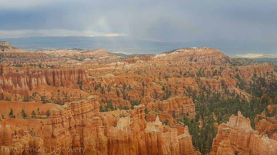
Bryce Canyon National Park’s scenic drive
One of my favorite parks in the United States is Bryce Canyon National Park in Utah. The whole park is a high-altitude mesa (not a canyon oddly enough). On the east side of the mesa the forces of nature have carved a series of hoodoos, rock spires, out of the Navajo sandstone.
While I certainly recommend getting out of the car and hiking down into the hoodoos, people who just drive the park road and pull out at the many vista spots will also enjoy this spectacular park. I recommend getting up and seeing the park at dawn if you can manage it for some of the best light, but do be aware that you are at around 8,000 feet in elevation and so the park has many nights during the year that will be below freezing. There are 100 days that the park freezes at night and then thaws during the day, and that cycle helped carve these hoodoos as ice cracked the rocks and the softer rock wore away.
The park road is a 38-mile scenic drive (round trip) to Rainbow Point which is the southern-most point. Plan on at least 3 hours for that drive but don’t rush. My 3 favorite stops on the park road are Sunset Point (and the trailhead for the Navajo Trail), Natural Bridge and Rainbow Point. Pack a picnic lunch as there is no food sold except near the park entrance and the Visitor center. If you are pulling a trailer you will only be able to go about a third of the distance, and will have to turn around just past Sunset Point.
Bryce Canyon is one of the highlights of a national park road trip in the American Southwest and can easily be combined with Zion National Park which is a few hours away.
Chris with Amateur Traveler
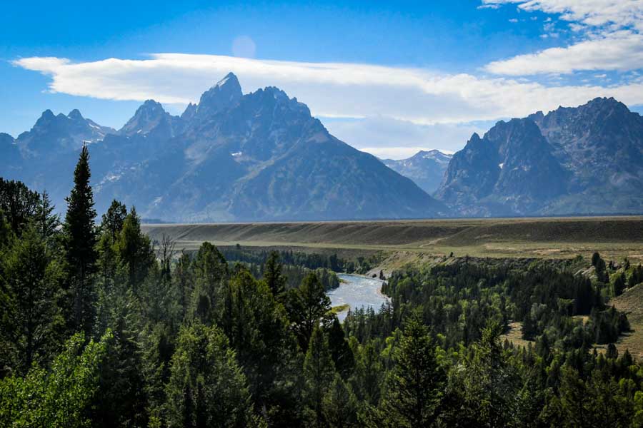
Grand Teton National Park and scenic drives
Grand Teton National Park is brimming with incredible viewpoints and scenic drives for all to enjoy. Truth be told, just about any road in the park’s vicinity is gorgeous. However, there are some iconic views you just won’t want to miss:
Seeing the iconic T. A. Moulton Barn: This landmark is one of the “musts” in Grand Teton National Park. Come at sunrise for the best lighting and fewer crowds than later in the day. Not far from this barn lies the historic Chapel of the Transfiguration, which is made from logs and is set against the dreamy backdrop of the Teton Mountain Range.
Moose-Wilson Road: Made famous in Ansel Adams’ 1942 photograph, this viewpoint offers views of the curving Snake River, flanked by the Tetons. While trees now obscure part of this iconic view, it’s still worth a quick stop.
Moose-Wilson Road: This winding road is known as being one of the best places in the park to spot wildlife without having to leave your car. For that reason, it gets quite busy and during peak season it can feel like a traffic jam at certain times of the day. Beat the crowds and leave early!
Jackson Lake: Just north of the national park lies stunning Jackson Lake. Drive north on highway 191, which brings you right next to this massive body of water. Pull over so you can fully take in the incredible sight of this lake with the Teton Mountain Range towering behind. If you have time, this is a great lake to rent a kayak or SUP and explore!
Katie with Two Wandering Soles
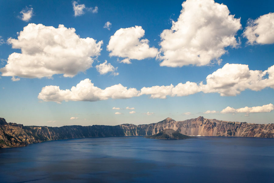
Crater Lake National Park – Rim Road Drive
Crater Lake formed after a volcanic eruption thousands of years ago that caused Mt. Mazama to cave in on itself. Over the course of time, snowmelt and rain pooled in the crater to create the deepest lake in the United States (1,943ft).
The best way to experience Crater Lake National Park is by driving the Rim Road, a 32.93-mile lap around the crater with plenty of jaw-dropping overlooks and refreshing hikes along the way.
Due to the park’s elevation, the average snowfall here is 48-feet, meaning the best time to visit is between July and September.
Three of the most popular areas are Watchman Peak, Cloudcap Overlook, and Cleetwood Cove, the first being a 1.6-mile roundtrip trail that leads to stunning 360-degree vistas around the park and lake below. It requires 387-feet of elevation gain over a short distance, but hikers of all ages to frequent the trail.
Cloudcap Overlook is famous not only for the views but also because it is only accessible via Oregon’s highest paved road while Cleetwood Cove is the only access point to the lake itself. Visitors can book a boat ride to Wizard Island or take a dip in the cool waters.
For a lesser-known but equally beautiful overlook, stop by Victor View. This unmarked area is the second pull-off on the left after passing Phantom Ship (driving counterclockwise around the rim). It’s the perfect lunch spot away from the crowds.
With a plethora of hiking and vistas, the Rim Road makes for the perfect National Park road trip!
Check out Christopher’s post on visiting Crater Lake National Park
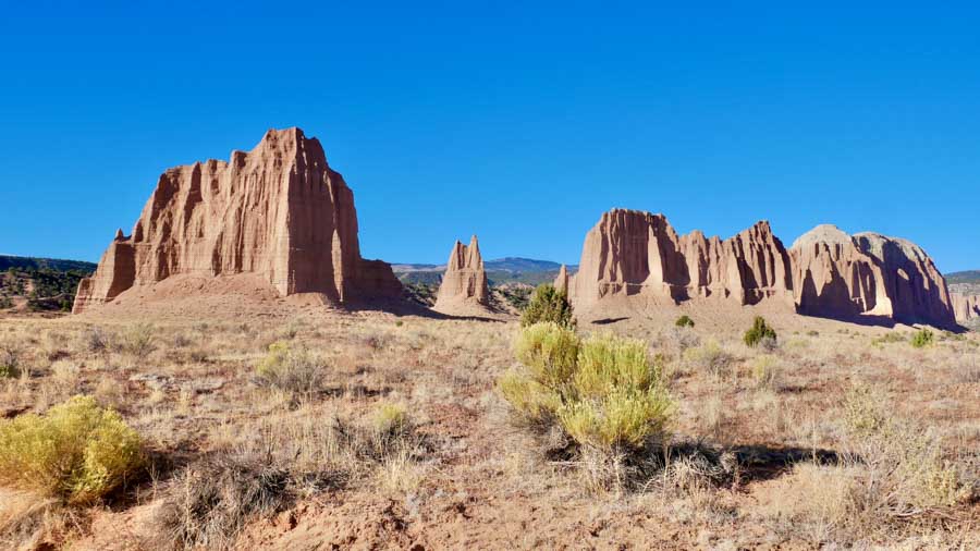
Cathedral Valley Loop in Capital Reef National Park
The Cathedral Valley is a remote region of Utah’s Capitol Reef National Park. It boasts red rock hillsides, soaring monoliths, vast desert vistas, and lonely unpaved roads. Though it is among the most photogenic areas in Capitol Reef, the area’s relative inaccessibility makes it an off-the-beaten-path gem. A 57.6-mile loop showcases the most spectacular attractions in the Cathedral Valley. It weaves in and out of the national park’s boundaries and reveals breathtaking desert vistas at every bend.
The iconic Temples of the Sun and Moon are undisputed highlights of the Cathedral Valley Loop. You can camp for free on the BLM land adjacent to the temples. Doing so will enable you to visit at sunrise. In the early morning hours, their fiery glow is particularly striking.
In addition to the Temples of the Sun and Moon, the scenic road features three must-see panoramic viewpoints: The Cathedral Valley Overlook, and the Upper and Lower South Desert overlooks. The three overlooks afford some of the most dramatic vistas in Capitol Reef. They each require short quarter-mile hikes. Near the Cathedral Valley Overlook, you’ll find a primitive campground with six tent spots.
Capitol Reef’s Cathedral Valley Loop is not for the rushed or faint of heart. It is a time-consuming and treacherous backcountry road that requires fording a river and negotiating deep pockets of sand. Its washed-out roads and potholes create the perfect conditions for getting stuck if you’re traveling unprepared. Do not attempt the route unless you have a reliable 4WD vehicle.
Before beginning your journey, make sure you double-check road and weather conditions. Though the loop is open year-round, it should be avoided at all costs when there is an elevated risk of flash floods.
Erika Bisbocci with Erikas Travels
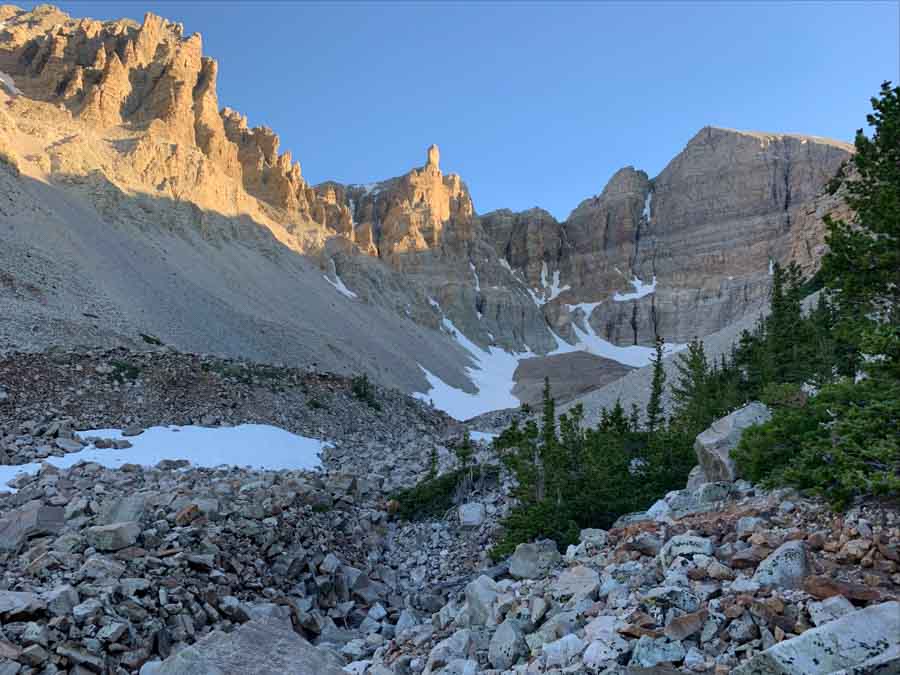
Great Basin National Park
A trip along Wheeler Peak Scenic Drive offers amazing vistas of the beautiful and unique landscape of Great Basin National Park. Located in eastern Nevada, the highlight of this drive is the sight of Wheeler Peak (the second highest mountain in Nevada at 13,065 feet), but the views of rugged terrain and the Snake River mountain range make the entire 12 mile drive memorable.
Start your drive near the Lehman Caves Visitor Center at the entrance of the park. The road is paved the whole way, but it is narrow, and you will be ascending fairly steeply with plenty of twists and turns. Take it slow, so you can appreciate the views as you go. As you gain elevation – around 4,000 feet total – the landscape will transform around you. Wheeler Peak Scenic Drives starts in the desert sagebrush and shrubs then heads through pinyon pines and mountain mahogany, until you eventually reach conifer forests and alpine groves.
Make sure to stop at Mather Overlook, about 8 miles into the drive, where you’ll encounter your first sight of Wheeler Peak itself. After another mile, you’ll reach Wheeler Overlook, with even more stunning views. At the end of the Wheeler Peak Scenic Drive, you’ll find the trailheads for the Wheeler Peak Summit Trail and the Bristlecone-Glacier Trail, two of the best hikes in Great Basin National Park.
Be aware that Wheeler Peak Scenic Drive closes completely in the winter, usually at some point in November, and generally reopens around Memorial Day.
Allison – She Dreams of Alpine
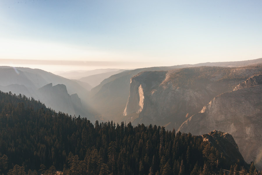
A scenic road trip in Yosemite National Park
Yosemite Valley is one of the most popular parts of Yosemite National Park. But did you know you can see it from above? The scenic Glacier Point Road is an essential part of any Yosemite National Park itinerary. It takes you high above Yosemite Valley to some spectacular hikes and viewpoints.
Glacier Point Road is a 15-mile-long scenic drive ending at Glacier Point. But Glacier Point Road has so much more to offer than just its final, stunning viewpoint.
As you navigate the windy road, you’ll pass some of the best hikes in the park: Sentinel Dome and Taft Point. These trails are best hiked at sunset, so head to Glacier Point first before returning for a sunset hike.
From the Glacier Point parking lot, it’s a short walk to the viewpoint. Here you’ll see unparalleled views of Half Dome and Yosemite Valley below. In the spring and summer, you can spot Yosemite Falls from here too!
After exploring Glacier Point, head back to hike Sentinel Dome. Although you can get here from the Glacier Point Trailhead, it’s better to hike this trail as a loop from the Taft Point Trailhead. Parking can be hectic here in the afternoons, so you may have to park along the road and walk a bit to get to the trailhead.
Plan to start this hike about 2 hours before sunset for the best views. Hike to Sentinel Dome first, then to Taft Point in a counter-clockwise loop.
From the top of Sentinel Dome, you’ll have 360-degree views of Yosemite National Park. Sunset at Taft Point is miraculous, with perfect views of El Capitan and the distant Sierras.
Glacier Point Road is typically open from May to November, but the opening and closing dates change every year due to snowfall.
Julia with Well Planned Journey
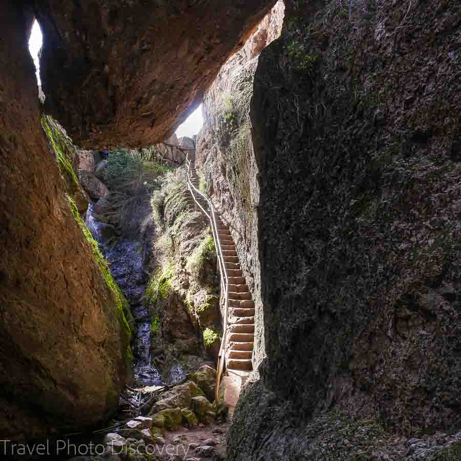
Pinnacles NP – Pinnacles Highway
Pinnacles National Park has two major entrances one the east and one of the west. The entrance on the west is very winding and narrow and the east entrance tends to be more popular. The east and the west roads do not connect so you can go to one side or the other.
The east entrance is visited more often for the park’s campsite. It’s a beautiful drive in the winter months after the rain and in spring when the wild flowers bloom. In summer and fall it’s quite dry.
Driving up from the camp grounds, there are several stops, each with parking lots and hikes. Since Pinnacles and a newer and smaller national park, parking is usually easily available and the trails aren’t too busy. It’s an easy day trip from the Sam Francisco Bay Area so it’s invites local traffic.
The main views along the Pinnacles Highway are those of the towering rock structures and mountains. There is also a large waterfall on the route from the visitor center to the main parking lot for hikers at Bear Gulch.
Bear Gulch is one of the best places to park for hikers. The cave hikes are great for kids and “Pinnacle National Park photography” The trails and the restroom are across the street from the Bear Gulch parking lot. There is water station to fill your water bottles. Be sure to take plenty of water as the hikes have decent elevation gain and it can get quite hot in the sun.
Jyoti with Story at Every Corner
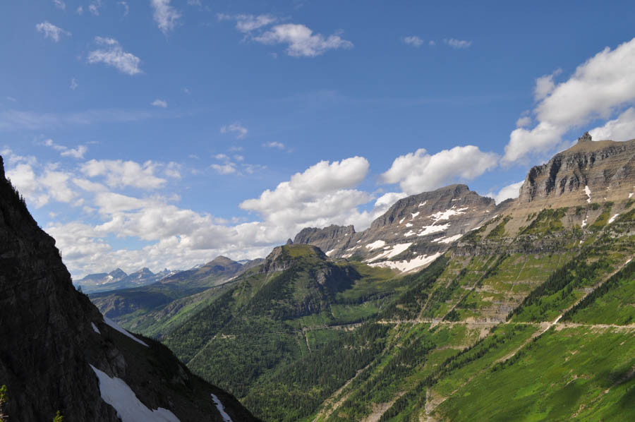
Road to the Sun at Glacier National Park
Best Scenic Drives in a USA National Park has got to be in Glacier National Park in Montana. The Going-to-the-Sun Road is recognized as one of the most beautiful drives in all of the USA. Known as the Crown of the Continent, Glacier National Park’s majestic mountains jut up into the sky and the road is carved into the side at just the right spot, bringing visitors incredible views of the park.
Going-to-the-Sun Road is one of the best things to do in Glacier National Park. It can be driven from either the east entrance of the park, at the St. Mary Visitor Center or the west entrance of the park at the Apgar Visitor Center. Visitors should plan their trip accordingly as the road doesn’t open fully until the middle of summer.
Due to massive snowfall in northern Montana, the snow typically melts and the road opens completely by mid-July. Therefore, the best time to visit Glacier National Park and experience this scenic drive is mid-July through mid-September.
While the entire drive is fantastic, the highlights of the Going-to-the-Sun Road are stopping at the reflective Lake McDonald. There are many spots to stop along Lake McDonald, all with the gorgeous backdrop of the mountains in the distance.
Make your way through Logan Pass, which is the highest point in the park on 4 wheels, and also happens to be the continental divide. Be sure to hike the Hidden Lake Trail, which provides scenic views of wildflowers and alpine lakes throughout the duration of the hike.
Saint Mary Lake is another highlight on the Going-to-the-Sun Road. It’s a gorgeous alpine lake perfect with multiple scenic outlooks. The surrounding waterfalls will awe you, with day hikes to Baring Falls or Virginia Falls.
Glacier National Park is an amazing destination for nature lovers. Spend at least 2 days exploring the park or up to a week. Without a doubt, the Going-to-the-Sun Road is one of the best scenic drives in a USA National Park.
Nikki with She Saves She Travels
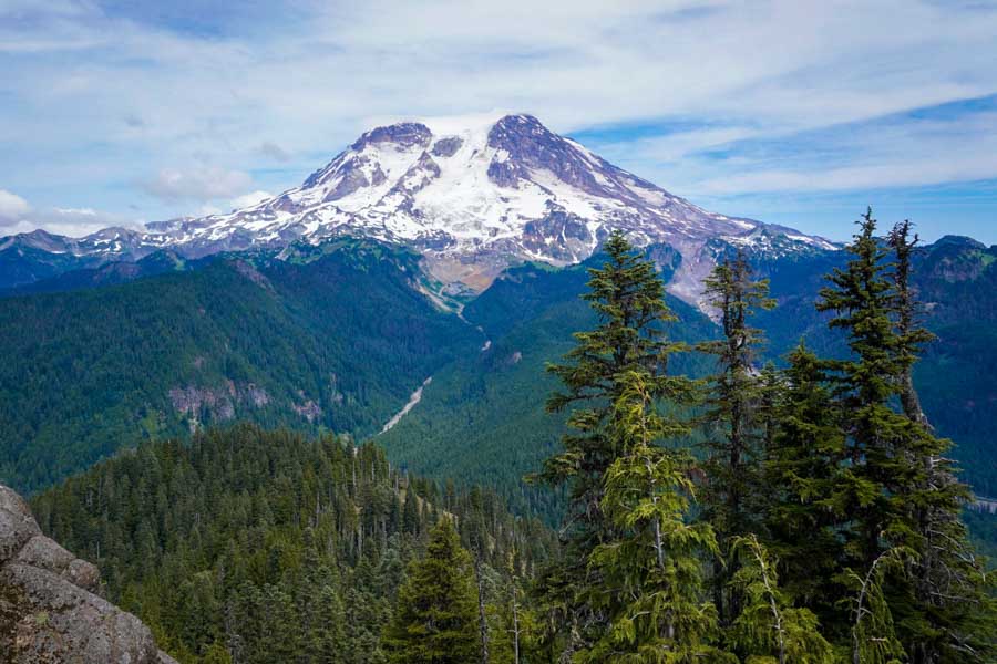
Chinook Scenic Bayway, Central Cascades
The Chinook Scenic Byway is a 92 mile drive winding through the Central Cascades and arguably the best scenic drive in Washington state. Over the course of the three hour drive (assuming you’re able to resist the urge to constantly pull over and take pictures of the gorgeous landscape), the road will take you through some of the best hiking spots in the Pacific Northwest, including through Mt. Baker-Snoqualmie National Forest and Mount Rainier National Park. The road traverses diverse landscapes, from the glacier-fed White River Valley to the wildflower pastures of Naches. Along the drive, you’ll catch breathtaking views of Mount Rainier, the tallest mountain in the state; fecund rainforests; the endless layers of the Cascade Mountain range; and stunning waterfalls.
Given the spectacular scenery, there’s, of course, endless opportunities to explore the great outdoors. In the summertime, consider stand-up paddle boarding at Bumping Lake, lacing up those hiking boots and taking on the Skyline Trail in Mount Rainier National Park, or camping at any of the myriad of campgrounds along the route. The summertime is also the best time to spot wildlife- while you’re in the National Park, stop by Tipsoo Lake to try to catch some hoary marmots and mule deer and all along the route, keep your eyes peeled for bears, elk, and mountain goats. While portions of the road are closed in the wintertime due to heavy snow, you can still access the beloved Crystal Mountain Ski Resort, for all the fresh powder your heart desires. If down-hill skiing or snowboarding aren’t your cup of tea, consider instead snowshoeing along any one of the six non-motorized trails or snowmobiling the popular Greenwater Snowmobile Route, a 42-mile loop winding through an alpine forest. Regardless of what time of year you drive the Chinook Scenic Byway, you’ll be sure to be dazzled by the beautiful scenery and boundless activities that await you!
Jessica with Uprooted Traveler
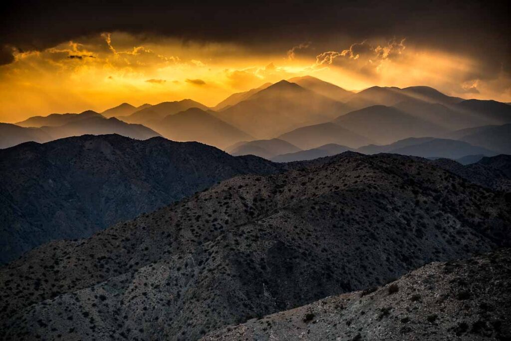
Joshua Tree National Park
As we entered Joshua Tree National Park, we asked the ranger at the visitor’s center where’s the best place to see the Joshua Tree desert sunset. Without hesitation, she said, Keys View. Wow, was she right?
The road to Keys View at Joshua Tree is dotted with interesting scenes, including the so-called Jumbo Rocks, which are probably worth a photo stop. But the main objective is to get to the end of the road at Keys View that overlooks the interesting desert formations around the San Andreas Fault. From the 5000-foot-high spot, you can also look down to see the sun glinting off the famous glass-walled homes in Palm Springs, 15 miles in the distance.
Save Keys View for the sunset. If you are early, take a short detour off your route and make time to walk into Hidden Valley. The aptly named valley is completely surrounded by stunning rock formations and dotted with desiccated mesquite, which can make stunning photos as well.
When you get to Keys View, a little before the sun sets over the fault, you’ll have to walk up a paved path from the parking lot to the designated observation spot. It’s likely that a lot of people will be there with you also shooting into the western sun. But, take your time and work to get a unique perspective. Use a polarizing filter and make multiple exposures. If you’re lucky, the sun will filter through the clouds and you’ll have a couple of minutes when you are presented with a really spectacular view.
Tom with Travel Past 50
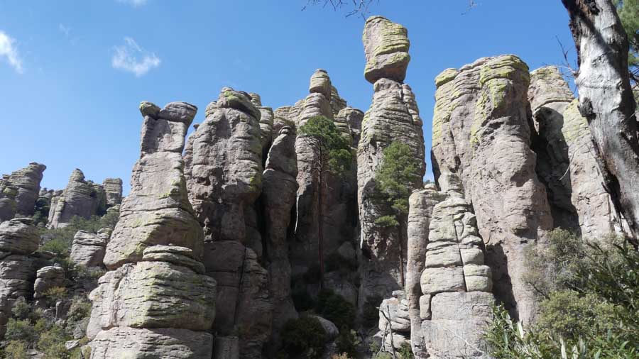
Chiricahua National Monument
Chiricahua National Monument is the place to see nature’s art. This little gem boasts awe-inspiring rock formations, balanced rocks and spectacular views all around. Chiricahua is a 2-hour drive from Tucson Arizona and a fantastic lesser-known Park on a Southwestern road-trip.
Upon arrival, travel up the 8-mile Bonita Springs Road, climbing from the Visitor Center to approximately 7000 feet. While driving, behold the towering rock formations looming overhead. There are pullouts to view and photograph nature’s unique formations.
Drivers must keep eyes on this narrow winding road that hugs the rockface on one side and a cliff on the other. The valley views along the drive down are breathtaking.
Drive or hike to be awed by Mother Nature!
Drive for views:
- First viewpoint on Bonita Springs Road – a left-hand pull-off just past the Visitor Center for unique rock columns.
- Second left-hand pull-off – a viewpoint to photograph the inimitable rock pinnacles.
- Third pull-off on the right – step through the trees to photograph the rock pillars.
- On the left – Natural Bridge Trail pull-off to spot wildlife or view the beautiful rock formations across the road.
- Echo Point parking – look to the right for a great photo of a small set of balanced rocks.
- At Massai Point, the top lot – follow Massai Nature trail for exquisite panoramas of mountain ranges, balanced rocks, and valleys.
Hike for great photos:
- Echo Canyon Grottoes – an easy short loop trail to walk through and photograph rock formations up-close.
- On Heart of Rocks Loop – A strenuous hike accessed from Massai Point or the Echo Canyon parking lot – find many photo opportunities, like Duck on a Rock, Punch and Judy, Pinnacle Balanced Rock.
- Inspiration Point – Accessed from Massai Point, see excellent views of Cochise Head and Rhyolite Canyon.
- The Natural Bridge hike starts from 1 mile past the Visitor Center, taking hikers from the base to a ridge above the spires mid-mountain. A moderate hike providing photo opportunities of the flora and pinnacles.
- For wildlife – Hike the easy Visitor Center to Campground, Bonita Creek, and Lower Rhyolite Canyon Trails for a chance to see and photograph Coatimundi and Javelina during early morning or afternoon feeding times.
There is a small pull-off for Natural Bridge and two larger lots at the top for Echo and Massai Points. Parking is also available at the Visitor Center. In non-Covid times, there is a hiker’s transport at 9 AM from the Visitor Center to Echo and Massai Points; these strenuous hikes range from 7.5 to 9.5 miles top to bottom.
Chiricahua National Monument, in the Coronado National Forest, will not disappoint! We have visited twice for 2-3 days each time and we will go back.
Check out Wendy’s post on Arizona Destinations in the USA
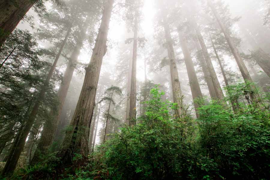
Redwood National Park
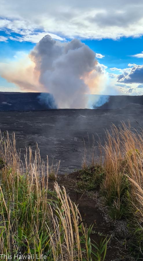
Chain of Craters Road, Volcanoes National Park – Big Island
One of the best reasons now to visit Volcanoes National Park on the Big Island of Hawaii is to experience the live lava eruptions in the heart of the crater at Halema’uma’u in the central caldera that impressively dominates the heart of the park area. There are many overlook areas that you can drive up to and explore and then take the scenic road on the Chain of Craters Road down to the ocean area. Along the way are impressive outlooks, hiking trails and lush forests to discover some of which are worth stopping below.
Kilauea Lodge and Overlook area
Rim Trail and Overlook area at the Caldera
Thurston Lava Tube
Kilauea Iki Trail and devastation Valley
Pu’uloa Petroglyph hiking area
Holei Sea Arch at the end of Chain of Craters Road
You’ll enjoy exploring Volcanoes National Park and driving through the scenic Chain of Craters road. While visiting Hawaii island, make sure to explore the east side and Hilo attractions here for more inspiration and fantastic places of interest to visit on the Big Island.
Noel with This Hawaii Life
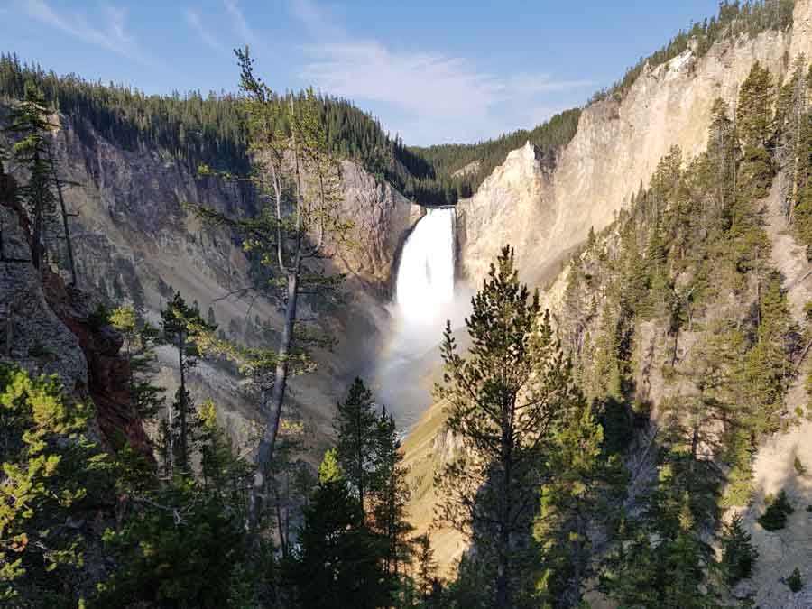
Lower Loop of Yellowstone
One of the best scenic drives in a US National Park is the Lower Loop of Yellowstone. The lower part of the Grand Loop is approximately 100-miles long and covers some of the best places to visit in Yellowstone.
To drive the loop and stop to explore some of the best parts of Yellowstone, you will need to allow a full day. Set off early in the morning from Madison Junction and head to the Grand Prismatic Spring. Parking is at a premium later in the day, but arrive before 9am and you should be lucky to find a spot. There are some hikes that will take you to higher ground for the best pictures of the spring from above.
From the spring, head south to Old Faithful and explore the other geothermal features near these most famous geysers. You can check the board in the Visitor’s Centre for approximate time for the next eruption.
Further east and north on the Lower Loop road is the West Thumb Geyser Basin followed by Yellowstone Lake, leading to the Hayden Valley. It is here you will be likely to spot herds of bison. There are pulling-in places along the valley, just drive slowly and indicate as early as possible. And if there is a traffic jam, it’s probably due to bison.
The road meanders along with the Yellowstone River until it reaches Canyon, where you can view the two main waterfalls in Yellowstone. Walk down to the lower lookout point for the best views of the Lower Falls of the Yellowstone River. It’s a hike back up for those who are not very fit.
From Canyon you head west via Norris back to Madison. However, make sure not to miss Gibbon Falls along this road. It is not the biggest waterfall in Yellowstone but is one of the prettiest.
This route is family-friendly and with plenty of places to stop along the way, it makes Yellowstone one of the best US National Parks for families. Plan to bring snacks and drinks and don’t forget your camera and binoculars.
Cath with Passports and Adventures
Eastern US national parks road trips
Doing an Eastern US National Parks road trip unveils a tapestry of natural wonders and cultural heritage. From the lush forests of the Great Smoky Mountains to the pristine beaches of Acadia, these parks offer a diverse range of landscapes and experiences. Explore the ancient Appalachian Mountains, witness vibrant fall foliage, and discover historic sites along the way. Immerse yourself in the rich biodiversity, hike scenic trails, and marvel at picturesque waterfalls. An Eastern US National Parks road trip promises a captivating journey through stunning vistas, rich history, and unforgettable encounters with nature.
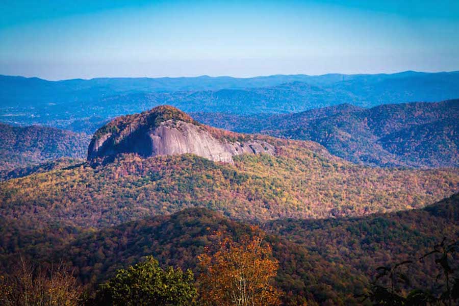
Blue Ridge Parkway (North Carolina/Virginia)
It may surprise you to learn that the Blue Ridge Parkway is the most visited of all the national park units in the United States, attracting more than 15 million annual visitors. But if it does, it’s probably only because you haven’t explored this iconic scenic route.
The BRP’s origins date back to 1935, when President Franklin Delano Roosevelt came up with the concept of a road stretching all the way from the entrance to Great Smoky Mountains National Park in North Carolina to the entrance to Shenandoah National Park in Virginia (where it turns into the equally scenic Skyline Drive). It was an historic conservation initiative, part of FDR’s famous New Deal, which was designed to improve American infrastructure and create good jobs as a means to accelerate the nation’s economic recovery after the Great Depression.
It took more than three decades (until 1966) to construct the majority of the road’s 469 miles, and another 21 years to complete what many people consider the BRP’s most picturesque stretch, from North Carolina’s Linn Cove Viaduct to the monolithic Grandfather Mountain.
In addition to the National Parks, driving the Blue Ridge Parkway takes you through some of the most important wilderness conservation areas in the eastern United States. There’s the Jefferson, George Washington, Nantahala, and Pisgah National Forests; numerous impressive state parks (including NC’s Mount Mitchell State Park, home to the highest peak east of the Mississippi); and countless hiking trails, waterfalls, rivers, lakes and streams. All of these are home to an array of endemic animals, including Black Bear, White-tailed Deer, Wild Turkeys, and countless other birds.
Located less than half a day’s drive from most major cities in the eastern US, the Blue Ridge Parkway is perfect for weekend road trips (if you break it up into sections) or longer vacations. The speed limit along the entire route is 45mph, so it’s possible to drive its length in 15 hours if you don’t make any stops along the way. But why would you want to, when there are some 200 breathtaking Blue Ridge Parkway overlooks, as well as beautiful Blue Ridge Mountain towns such as Boone, Banner Elk, and Little Switzerland NC?
The best of these landmarks– including Grandfather Mountain State Park, the Linville Gorge Wilderness, Looking Glass Rock, and Julian Price Memorial Park– offer exquisite opportunities to savor the splendor of America’s wilderness at its most pristine, preserved by FDR for future generations to enjoy.
Bret Love & Mary Gabbett of Blue Ridge Mountains Travel Guide
Skyline Drive, Shenandoah National Park
One of the most beautiful national parks in the eastern U.S. features a scenic drive that puts all that beauty within easy reach. Shenandoah National Park straddles the Blue Ridge Mountains in Virginia, and scenic Skyline Drive stretches 105 miles along the center of the park. Because the drive follows a ridgeline, visitors enjoy stunning views from both sides of the park.
Many of the best stops and activities are in Shenandoah National Park’s Central District. Here, Skyline Drive offers easy access to excellent hiking, overlooks, park lodges, and visitor centers. During your drive, stop at a mix of eastward and westward-facing viewpoints. Hazel Mountain, Jewell Hollow, Thoroughfare Mountain, and The Point are four of the best overlook views in the park. The Harry Byrd Visitor Center at Big Meadows shares the park’s interesting history, geology, and nature. Skyline Drive was built by Depression-era CCC workers and many families were displaced during the park’s creation.
Over 500 miles of trails crisscross Shenandoah Park, including over 300 miles of the Appalachian Trail. Favorite hikes from Skyline Drive include Stony Man, Hawksbill, Dark Hollow Falls, and the wheelchair-accessible Limberlost Trail. Reward your effort with a meal at one of two classic lodges—Skyland and Big Meadows—followed by blackberry ice cream pie, a local favorite. Stay in one of the lodges or campgrounds and you can enjoy both sunrise and sunset from the overlooks.
Skyline Drive begins in Front Royal Virginia, just 70 miles west of Washington DC. The park is close enough to visit on a day trip from DC, but we recommend a longer stay to enjoy all that the park has to offer.
Julie McCool with Fun in Fairfax VA
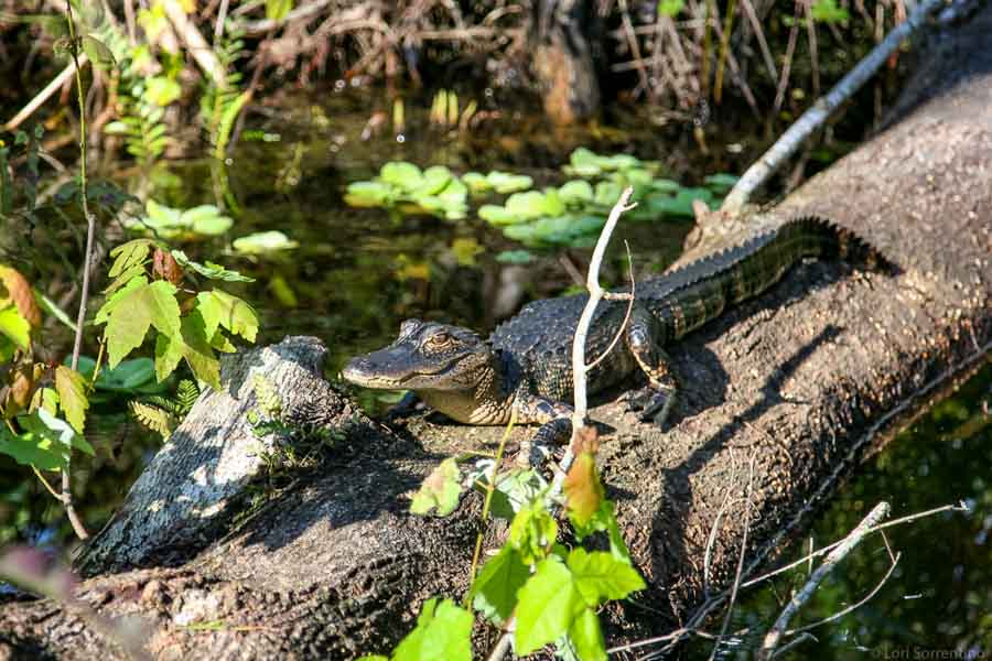
Everglades National Park
The Everglades evokes visions of alligators, heavily forested woodlands, and open grass marshes. Unknown to many, the “Everglades” is divided into the Fakahatchee Strand Preserve State Park which is part of Big Cypress and the Everglades National Park.
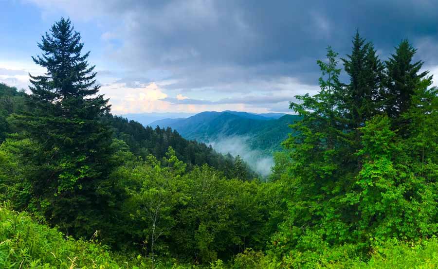
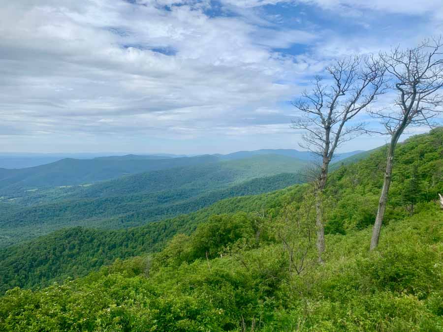
Newfound Gap Road in Great Smoky Mountains National Park
With just over 522,000 acres, the Great Smoky Mountains National Park is one of the largest in the country. And there’s no better way to traverse the mountain peaks, valley floors and catch a glimpse of extraordinary wildlife and spectacular views than to traverse the park via the Newfound Gap Road.
Newfound Gap Road is the longest stretch of pavement in the park, connecting the Sugarlands Visitor Center outside of Gatlinburg, Tennessee and the Oconaluftee Visitor Center outside of Cherokee, North Carolina. Though the road is only 30 miles each way, it could take around 1.5 hours if you drive slowly and immerse yourself in the breathtaking overlooks along the way.
Cutting through the heart of Great Smoky Mountains National Park, Newfound Gap Road features about 20 overlooks that veer every direction and give off the most breathtaking panoramic views without having to step foot on a hiking trail.
Its namesake, the Newfound Gap Overlook, sits at the North Carolina-Tennessee border, where visitors can stand in both states at the same time and veer into the abyss of mountains seemingly filled with smoke. While driving, keep your eyes peeled, because bear, elk and a variety of other wildlife and birds can be seen right off the side of the road.
Newfound Gap Road is also filled with the best hiking trails in the park. Along the road, hikers can find the trailheads to Alum Cave and Chimney Tops trails, which are the two best-rated in the park. A short pit stop can take you to Clingmans Dome, Grotto Falls and a slew of other spectacular hiking trails in the park.
Jerrod with Ramble Around the World
–
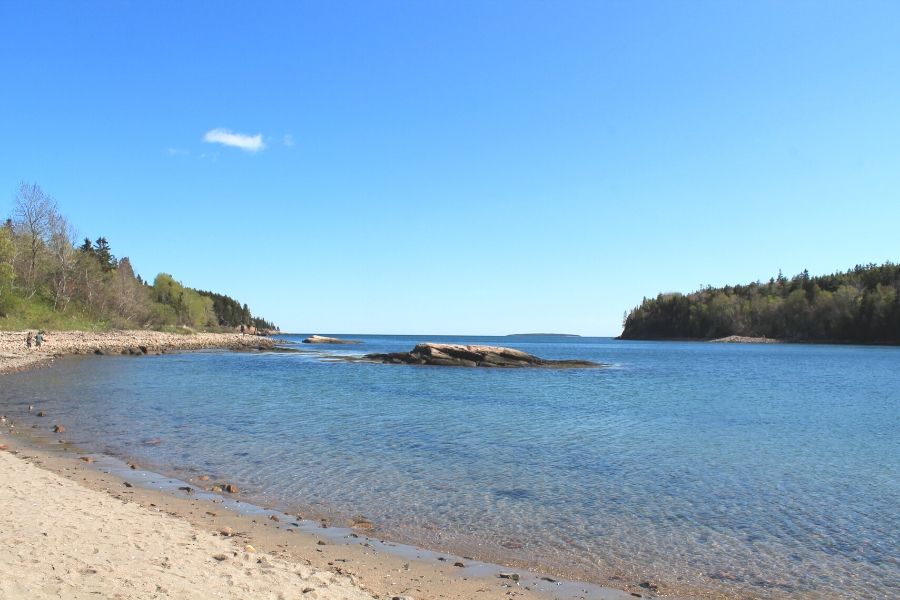
Acadia National Park
Maine, a state that is so beautiful is truly a photographer’s dream and a complete gem in the state is the Acadia National Park. The national Park boasts of a diverse landscape from rocky cliffs to mountains to ponds. A road trip across this 47,000 acre wide area by the Atlantic Coast gives you with a variety of magnificent vistas that will leave you mesmerized.
The best way to get a feel of the national park is by driving the 27-mile long Park Loop Road. The road traverses through multiple scenic spots like Thunder Hole, Sand Beach, Otter Cliff, Jordon Pond and many more along the loop. Most of the attractions have parking spaces to pull off, but during peak season they tend to get full. It is advisable to use the free Island Explorer Shuttle instead. Most of the Park Loop road is one-way traffic with detours to places like Cadillac Mountain.
Cadillac mountain is the park is considered the highest peak in the East coast and first place to see the rising sun in the US. The winding drive up to the peak is breathtakingly beautiful. Watching the sunrise from the summit is one of the best things to do. It gets very windy at the peak and hence it is advisable to carry blankets and jackets.
There is an entrance fees to avail the pass to Acadia National Park which is valid for 7 days of purchase.
Spring to Fall is a great time to take the road trip while most parts of the park get closed in winter. Fall is a very popular time with an advantage of viewing the colorful foliage, a sight to behold.
By Neha from Travelmelodies
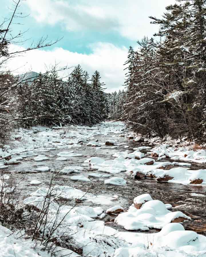
The White Mountain National Forest
The Kancamagus Highway – or “The Kanc,” as the locals call it – is a 34.5-mile scenic byway that runs along New Hampshire’s Route 112 through the White Mountain National Forest. In addition to its status as one of New England’s most scenic routes, it’s also one of the best foliage points in the United States. After the leaves have fallen, this mountainous landscape transforms into a winter wonderland, providing a proverbial playground for cross-country skiers, hikers, and snowmobilers.
The Kanc is highly conducive to exploration and photography, offering numerous parking areas for drivers to pull off and traverse the spectacular scenery. Travelers should have their cameras at the ready for the bevy of photo opportunities and lookout points that await. These include Russell-Colbath Homestead, CL Graham Wangan Overlook, Albany Covered Bridge, Sugar Hill Scenic Overlook, Rocky Gorge scenic area, and Swift River.
Given its remote nature, there are no rest stops along The Kancamagus Highway. In addition, cell phone service is minimal at best and non-existent at worst. For these reasons, visitors should fuel up and adequately prepare before hopping on and “wandering where the WiFi is weak.” In addition, travelers should also come equipped with access to Google Maps or a physical map, in case cell service is unavailable. Autumn tends to draw the biggest crowds, so fall visitors should get an early start, as parking will likely be more limited. Ideally, travelers should set aside about two to three hours to accommodate driving time and stops along the way.
Check outElena’s post on a New Hamsphire in winter post
More inside tips on doing a road trip around the USA National Parks
When embarking on a road trip around the USA National Parks, here are some inside tips to enhance your experience:
Plan Ahead: Research and plan your itinerary in advance. National Parks can be vast, and having a rough idea of the parks you want to visit, their distances from each other, and the time needed at each location will help you make the most of your trip.
Get an Annual Pass: Consider purchasing the America the Beautiful Pass, also known as the National Parks Pass. It grants you access to more than 2,000 federal recreation sites, including national parks, for a year. It can save you money if you plan to visit multiple parks.
Be Flexible: While planning is important, be open to flexibility. Weather conditions, park closures, and unforeseen circumstances can impact your itinerary. Have alternative routes and destinations in mind to adapt to any changes.
Start Early: Arriving at the parks early in the morning allows you to beat the crowds and enjoy the tranquility of the natural surroundings. Additionally, some parks have limited parking capacity, so arriving early improves your chances of finding parking spots.
Pack Essentials: Pack plenty of water, snacks, and sunscreen, especially for parks with limited services. Carry a map, guidebook, or use offline maps on your smartphone for navigation, as some parks have limited cell service. Don’t forget to bring appropriate clothing and footwear for outdoor activities.
Stay Inside or Nearby: Consider staying inside the park or in accommodations nearby to maximize your time in nature. Campgrounds, lodges, and cabins are available in many parks, providing a unique experience of being close to the wilderness.
Respect Nature and Wildlife: Follow park regulations and practice Leave No Trace principles. Preserve the beauty of the parks by not littering and respecting wildlife. Keep a safe distance from animals and never feed them.
Take Hikes and Scenic Drives: Explore the parks on foot by taking hikes or scenic trails to fully immerse yourself in their beauty. Drive along scenic routes within the parks to enjoy breathtaking views and photo opportunities.
Capture Memories: Bring your camera or smartphone to capture the stunning landscapes and wildlife encounters. Take your time to appreciate the scenery and create lasting memories.
Connect with Park Rangers: Engage with park rangers who have a wealth of knowledge about the parks. Attend ranger-led programs, guided hikes, or talks to gain deeper insights into the park’s history, geology, and ecology.
Pin this for later on your travel board
Conclusion on the Best USA National Parks scenic road trips
Doing a scenic road trip around the USA National Parks is a remarkable way to immerse yourself in the beauty and diversity of the country’s natural landscapes. Whether you explore the majestic mountains of the West, the captivating wilderness of the East, or the enchanting vistas of the Central region, each road trip offers a unique and unforgettable experience. From the iconic landmarks to hidden gems, these national parks showcase the grandeur of nature and provide opportunities for outdoor adventures, wildlife encounters, and moments of serenity. By planning ahead, staying flexible, and embracing the journey, you can create lasting memories and a deeper appreciation for the remarkable beauty that the USA National Parks have to offer. So, hit the road, let the scenery unfold before you, and embark on a road trip that will leave you in awe of the natural wonders of America.
Hopefully some of these inspiration locations have given you some ideas about fun places to explore nearby or as a fun getaway destination around the country to explore soon.
Thanks for visiting and checking out this collaborative post on the Best USA National Parks scenic road trips. Bookmark this post for future reference when you are looking for some road trip inspiration to the national parks now.
Please do share this post with any of the social media icons on the side bar and thanks for visiting today!
Some links in this article on the Best USA National Parks scenic road trips are affiliates which provide a small commission to support this site at no extra cost to you. Thank you for reading, and happy travels

Trackbacks/Pingbacks